
Access the full WAEC Geography 3 (Practical & Physical Geography) Questions and Answers for 2025 here. This page will be updated with verified solutions to both the Objective (OBJ) and Essay sections before the exam begins. Make sure to refresh this page regularly for the latest updates and accurate answers.
Geography 3 (Practical & Physical Geography) 2025
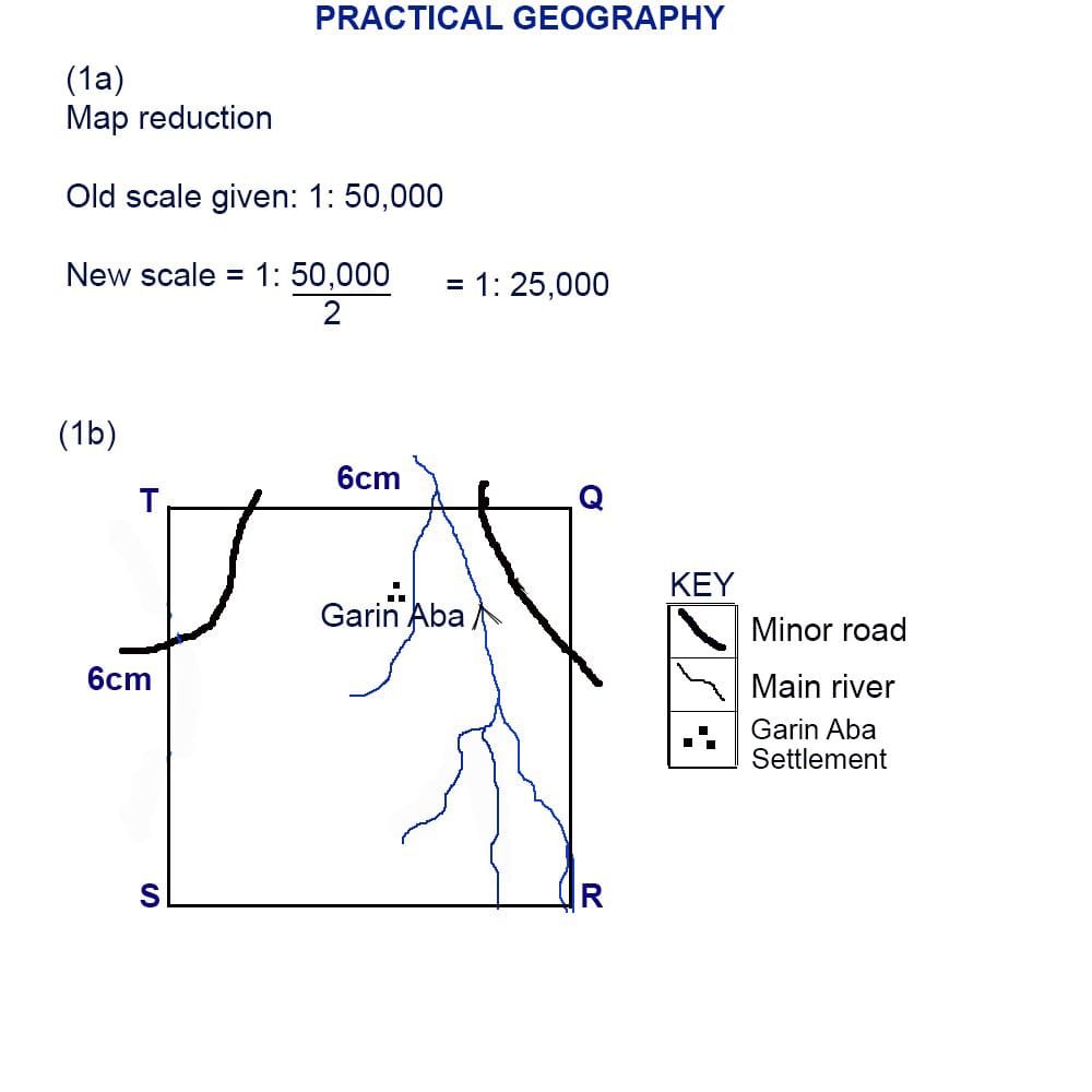
Number 1
(1a) & (1b)
(1c)
(i)Transport Junction: KARLAHI is located at the intersection of major and minor roads, making it a central hub for transportation and communication within the mapped area.
(ii)Largest Settlement: It is visibly the largest settlement on the map, indicating a higher population density and more developed infrastructure compared to other settlements.
(iii)Presence of Institutions: KARLAHI hosts key facilities such as a school, a market, and possibly other services (as shown by symbols), which attract people from surrounding areas for education, trade, and services.
(1d)
(i)Farming and Agriculture: The map shows extensive farmland and scattered rural settlements, indicating that crop farming and possibly livestock rearing are primary occupations.
(ii)Trading/Commerce: The presence of markets (indicated by market symbols) shows that trading is a significant economic activity, with goods likely being exchanged within and outside the region.
(iii)Education: The presence of schools (school symbol) suggests that teaching and educational services contribute to the local economy, providing employment and attracting students from nearby villages.
==================
Number 3
(3a)
The lithosphere is the outermost solid layer of the Earth, comprising the crust and the uppermost part of the mantle.
(3b)
(i)Rigid and brittle: The lithosphere is a rigid and brittle layer that can break and deform under stress, resulting in earthquakes and volcanic activity.
(ii)Composed of rocks: The lithosphere is made up of a variety of rocks, including granite, basalt, and sedimentary rocks.
(iii)Dynamic and in motion:The lithosphere is broken into several large plates that are in constant motion, resulting in plate tectonics and geological activity.
(3c)
(i)Source of minerals and resources: The lithosphere is a source of many valuable minerals and resources, including metals, fossil fuels, and construction materials.
(ii)Supports plant growth: The lithosphere provides the soil and nutrients necessary for plant growth, which is essential for agriculture and ecosystems.
(iii)Foundation for infrastructure: The lithosphere provides a solid foundation for buildings, roads, and other infrastructure, allowing humans to build and develop communities.
(iv)Habitat for organisms: The lithosphere provides a habitat for a wide range of organisms, from microorganisms in soil to plants and animals that live on and beneath the Earth’s surface.
(v)Stores Earth’s history: The lithosphere contains a record of the Earth’s history, including fossil evidence of past life forms and geological events.
==================
Number 4
(4a)
An artesian well is a type of well that taps into a confined aquifer, where water is under pressure and flows naturally to the surface without the need for pumping.
(4b)
(i)Presence of a Permeable Rock Layer (Aquifer): There must be a layer of porous and permeable rock (such as sandstone or limestone) that can store and transmit water.
(ii)Impermeable Layers Above and Below the Aquifer: The permeable aquifer must be sandwiched between two impermeable rock layers (such as clay or shale) to prevent water from escaping vertically.
(iii)Inclined Aquifer Structure: The aquifer must be tilted or inclined so that one end is exposed at a higher elevation to a recharge area, allowing water to enter and build up pressure.
(iv)Recharge Area at a Higher Elevation: The exposed end of the aquifer must be at a region of higher ground, where rainwater or surface water can infiltrate and recharge the aquifer, increasing the hydraulic pressure necessary for water to rise to the surface when a well is drilled.
(4c)
(i)Reliable water source: Artesian wells can provide a reliable source of water, especially in areas where surface water is scarce or unreliable.
(ii)Low maintenance: Since the water flows naturally to the surface, artesian wells require minimal maintenance and no pumping, making them a cost-effective option.
==================
Number 7
(7a)
(i)Deflation
(ii)Abrasion
(iii)Attrition
(7bi)
(i)Both Are Wind-Eroded Landforms: Zeugen and yardangs are formed primarily by the action of wind (aeolian erosion) in arid or semi-arid environments.
(ii)Elongated Shapes: Both landforms are elongated, ridge-like features that are typically aligned in the direction of prevailing winds.
(iii)Composed of Alternating Hard and Soft Rock Layers: Each landform develops where there are layers of resistant (hard) and less resistant (soft) rocks, allowing wind abrasion and deflation to sculpt their shapes.
(7bii)
(i)Formation Process:
-Zeugen: Formed mainly by wind abrasion along horizontal layers of alternating hard and soft rocks undercutting the soft layers beneath a hard cap.
-Yardang: Formed by both wind abrasion and deflation, with the wind cutting through vertical or gently sloping beds, creating streamlined ridges and troughs.
(ii)Rock Structure:
-Zeugen: Usually develop in areas with horizontal bedding planes of hard and soft rocks.
-Yardang: Often develop in regions with vertical or steeply inclined beds of rock.
(iii)Appearance and Size:
-Zeugen:Generally have a flat-topped appearance due to the hard cap rock, and are often larger and less streamlined.
-Yardang: Tend to be more streamlined, narrow, and pointed at the windward end, and are usually smaller than zeugen.
==================
Number 8
(8a)
The natural environment refers to the physical surroundings and ecosystem of the Earth, including the atmosphere, hydrosphere, lithosphere, and biosphere, that exist independently of human activity.
(8b)
(i)Deforestation: Large areas of forests are cleared for agriculture, urban development, and logging. This leads to loss of biodiversity, disruption of ecosystems, and contributes to climate change through increased carbon dioxide in the atmosphere.
(ii)Pollution: Human activities introduce harmful substances into the environment, such as industrial waste, plastic, pesticides, and oil spills. Pollution contaminates air, water, and soil, leading to health problems for humans and wildlife.
(iii)Overexploitation of Natural Resources: Excessive extraction of resources like minerals, fossil fuels, fish, and timber depletes these resources, disrupts habitats, and can lead to the extinction of species.
(iv)Urbanization and Land Degradation: The expansion of cities and infrastructure converts natural land into built environments. This causes habitat loss, soil erosion, and increased runoff, which can lead to flooding and reduced soil fertility.
(8c)
(i)Sustainable practices: Adopting sustainable practices such as renewable energy, sustainable agriculture, and reducing waste and pollution.
(ii)Conservation and protection: Establishing protected areas, conserving biodiversity, and protecting ecosystems and natural habitats.